Changes
On July 18, 2023 at 2:10:21 PM UTC,
-
Updated description of LoD3 Road Space Models from
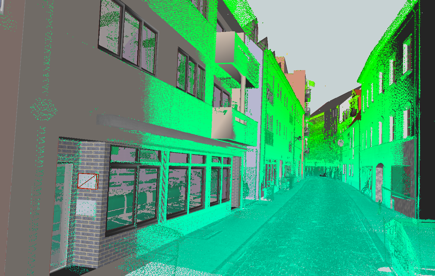
This [CityGML](https://www.ogc.org/standard/citygml/) dataset contains road space models (over 50 building models) in the area of [Ingolstadt](https://en.wikipedia.org/wiki/Ingolstadt). To ensure the highest accuracy geometrically as well as semantically, the dataset was manually modeled based on the mobile laser scannings (MLS) provided by the company [3D Mapping Solutions GmbH](https://www.3d-mapping.de/en/) (relative accuracy in the range of 1-3cm). Moreover, a complementary [OpenDRIVE](https://www.asam.net/standards/detail/opendrive/) dataset is available, which includes the road network, traffic lights, fences, vegetation and so on: <ul> <li>CityGML & SketchUp <ul> <li>Download via the <a href="https://github.com/savenow/lod3-road-space-models/releases">releases section</a></li> <li>Please note, that the 'Download ZIP' button doesn't include the project files due to <a href="https://git-lfs.com/">Git LFS</a> </li> </ul> <li>OpenDRIVE</li> <ul> <li>Download via the <a href="https://www.3d-mapping.de/en/customer-area/demo-data/">website of 3D Mapping Solutions</a> (initial registration required)</li> <li>Relevant OpenDRIVE dataset is named *Ingolstadt Innercity Halls* and can be found in the demo data area </li> <li>Conversion to CityGML can be carried out using the tool <a href="https://rtron.io">r:trån</a></li> </ul> </ul> Further Information: <ul> <li>Overview:<a href="https://www.3dcitydb.net/3dcitydb-web-map/1.6.1/3dwebclient/?title=Ingolstadt_CityGML_LoD3_Demo&shadows=false&terrainShadows=0&latitude=48.76421616414265&longitude=11.423261087465157&height=189.46220553536946&heading=170.97575939059712&pitch=-39.02715451772515&roll=0.03843163755915946&layer_0=url%3Dhttps%253A%252F%252Fwww.3dcitydb.net%252F3dcitydb%252Ffileadmin%252Fpublic%252F3dwebclientprojects%252Fingolstadt%252Fingolstadt_lod3%252Fkml_ingolstadt_trafficareas%252Fkml_ingolstadt_trafficareas_collada_MasterJSON.json%26name%3DIngolstadt_CityGML_TrafficArea%26active%3Dtrue%26spreadsheetUrl%3D%26cityobjectsJsonUrl%3D%26minLodPixels%3D0%26maxLodPixels%3D1.7976931348623157e%252B308%26maxSizeOfCachedTiles%3D200%26maxCountOfVisibleTiles%3D200&layer_1=url%3Dhttps%253A%252F%252Fwww.3dcitydb.net%252F3dcitydb%252Ffileadmin%252Fpublic%252F3dwebclientprojects%252Fingolstadt%252Fingolstadt_lod3%252Fkml_ingolstadt_auxiliarytrafficareas%252Fkml_ingolstadt_auxiliarytrafficareas_collada_MasterJSON.json%26name%3DIngolstadt_CityGML_AuxiliaryTrafficArea%26active%3Dtrue%26spreadsheetUrl%3D%26cityobjectsJsonUrl%3D%26minLodPixels%3D0%26maxLodPixels%3D1.7976931348623157e%252B308%26maxSizeOfCachedTiles%3D200%26maxCountOfVisibleTiles%3D200&layer_2=url%3Dhttps%253A%252F%252Fwww.3dcitydb.net%252F3dcitydb%252Ffileadmin%252Fpublic%252F3dwebclientprojects%252Fingolstadt_2%255Ckml_building_lod3_ingolstadt_neu%252Fkml_building_lod3_ingolstadt_collada_MasterJSON.json%26name%3DIngolstadt_CityGML_Building_LoD3%26active%3Dtrue%26spreadsheetUrl%3D%26cityobjectsJsonUrl%3D%26minLodPixels%3D0%26maxLodPixels%3D1.7976931348623157e%252B308%26maxSizeOfCachedTiles%3D200%26maxCountOfVisibleTiles%3D200&layer_3=url%3Dhttps%253A%252F%252Fwww.3dcitydb.net%252F3dcitydb%252Ffileadmin%252Fpublic%252F3dwebclientprojects%252Fingolstadt%252Fingolstadt_lod3%252Fkml_ingolstadt_sections%252Fkml_ingolstadt_sections_collada_MasterJSON.json%26name%3DIngolstadt_CityGML_Section%26active%3Dfalse%26spreadsheetUrl%3D%26cityobjectsJsonUrl%3D%26minLodPixels%3D0%26maxLodPixels%3D1.7976931348623157e%252B308%26maxSizeOfCachedTiles%3D200%26maxCountOfVisibleTiles%3D200&layer_4=url%3Dhttps%253A%252F%252Fwww.3dcitydb.net%252F3dcitydb%252Ffileadmin%252Fpublic%252F3dwebclientprojects%252Fingolstadt%252Fingolstadt_lod3%252Fkml_ingolstadt_intersection%252Fkml_ingolstadt_intersection_collada_MasterJSON.json%26name%3DIngolstadt_CityGML_Intersection%26active%3Dfalse%26spreadsheetUrl%3D%26cityobjectsJsonUrl%3D%26minLodPixels%3D0%26maxLodPixels%3D1.7976931348623157e%252B308%26maxSizeOfCachedTiles%3D200%26maxCountOfVisibleTiles%3D200"> Web-Map-Client</a> (LoD3 models combined with converted OpenDRIVE dataset)</li> <li>Creation guideline: <a href="https://creating-citygml-datasets.readthedocs.io/en/latest/creation-guidelines/lod3-models-based-on-point-clouds.html">Creating LoD3 Models Based on Point Clouds</a></li> <li> License:<a href="https://github.com/savenow/lod3-road-space-models/blob/main/LICENSE">(CC BY-SA 4.0)</a></li> </ul> 
toThis [CityGML](https://www.ogc.org/standard/citygml/) dataset contains road space models (over 50 building models) in the area of [Ingolstadt](https://en.wikipedia.org/wiki/Ingolstadt). To ensure the highest accuracy geometrically as well as semantically, the dataset was manually modeled based on the mobile laser scannings (MLS) provided by the company [3D Mapping Solutions GmbH](https://www.3d-mapping.de/en/) (relative accuracy in the range of 1-3cm). Moreover, a complementary [OpenDRIVE](https://www.asam.net/standards/detail/opendrive/) dataset is available, which includes the road network, traffic lights, fences, vegetation and so on: <ul> <li>CityGML & SketchUp <ul> <li>Download via the <a href="https://github.com/savenow/lod3-road-space-models/releases">releases section</a></li> <li>Please note, that the 'Download ZIP' button doesn't include the project files due to <a href="https://git-lfs.com/">Git LFS</a> </li> </ul> <li>OpenDRIVE</li> <ul> <li>Download via the <a href="https://www.3d-mapping.de/en/customer-area/demo-data/">website of 3D Mapping Solutions</a> (initial registration required)</li> <li>Relevant OpenDRIVE dataset is named *Ingolstadt Innercity Halls* and can be found in the demo data area </li> <li>Conversion to CityGML can be carried out using the tool <a href="https://rtron.io">r:trån</a></li> </ul> </ul> Further Information: <ul> <li>Overview:<a href="https://www.3dcitydb.net/3dcitydb-web-map/1.6.1/3dwebclient/?title=Ingolstadt_CityGML_LoD3_Demo&shadows=false&terrainShadows=0&latitude=48.76421616414265&longitude=11.423261087465157&height=189.46220553536946&heading=170.97575939059712&pitch=-39.02715451772515&roll=0.03843163755915946&layer_0=url%3Dhttps%253A%252F%252Fwww.3dcitydb.net%252F3dcitydb%252Ffileadmin%252Fpublic%252F3dwebclientprojects%252Fingolstadt%252Fingolstadt_lod3%252Fkml_ingolstadt_trafficareas%252Fkml_ingolstadt_trafficareas_collada_MasterJSON.json%26name%3DIngolstadt_CityGML_TrafficArea%26active%3Dtrue%26spreadsheetUrl%3D%26cityobjectsJsonUrl%3D%26minLodPixels%3D0%26maxLodPixels%3D1.7976931348623157e%252B308%26maxSizeOfCachedTiles%3D200%26maxCountOfVisibleTiles%3D200&layer_1=url%3Dhttps%253A%252F%252Fwww.3dcitydb.net%252F3dcitydb%252Ffileadmin%252Fpublic%252F3dwebclientprojects%252Fingolstadt%252Fingolstadt_lod3%252Fkml_ingolstadt_auxiliarytrafficareas%252Fkml_ingolstadt_auxiliarytrafficareas_collada_MasterJSON.json%26name%3DIngolstadt_CityGML_AuxiliaryTrafficArea%26active%3Dtrue%26spreadsheetUrl%3D%26cityobjectsJsonUrl%3D%26minLodPixels%3D0%26maxLodPixels%3D1.7976931348623157e%252B308%26maxSizeOfCachedTiles%3D200%26maxCountOfVisibleTiles%3D200&layer_2=url%3Dhttps%253A%252F%252Fwww.3dcitydb.net%252F3dcitydb%252Ffileadmin%252Fpublic%252F3dwebclientprojects%252Fingolstadt_2%255Ckml_building_lod3_ingolstadt_neu%252Fkml_building_lod3_ingolstadt_collada_MasterJSON.json%26name%3DIngolstadt_CityGML_Building_LoD3%26active%3Dtrue%26spreadsheetUrl%3D%26cityobjectsJsonUrl%3D%26minLodPixels%3D0%26maxLodPixels%3D1.7976931348623157e%252B308%26maxSizeOfCachedTiles%3D200%26maxCountOfVisibleTiles%3D200&layer_3=url%3Dhttps%253A%252F%252Fwww.3dcitydb.net%252F3dcitydb%252Ffileadmin%252Fpublic%252F3dwebclientprojects%252Fingolstadt%252Fingolstadt_lod3%252Fkml_ingolstadt_sections%252Fkml_ingolstadt_sections_collada_MasterJSON.json%26name%3DIngolstadt_CityGML_Section%26active%3Dfalse%26spreadsheetUrl%3D%26cityobjectsJsonUrl%3D%26minLodPixels%3D0%26maxLodPixels%3D1.7976931348623157e%252B308%26maxSizeOfCachedTiles%3D200%26maxCountOfVisibleTiles%3D200&layer_4=url%3Dhttps%253A%252F%252Fwww.3dcitydb.net%252F3dcitydb%252Ffileadmin%252Fpublic%252F3dwebclientprojects%252Fingolstadt%252Fingolstadt_lod3%252Fkml_ingolstadt_intersection%252Fkml_ingolstadt_intersection_collada_MasterJSON.json%26name%3DIngolstadt_CityGML_Intersection%26active%3Dfalse%26spreadsheetUrl%3D%26cityobjectsJsonUrl%3D%26minLodPixels%3D0%26maxLodPixels%3D1.7976931348623157e%252B308%26maxSizeOfCachedTiles%3D200%26maxCountOfVisibleTiles%3D200"> Web-Map-Client</a> (LoD3 models combined with converted OpenDRIVE dataset)</li> <li>Creation guideline: <a href="https://creating-citygml-datasets.readthedocs.io/en/latest/creation-guidelines/lod3-models-based-on-point-clouds.html">Creating LoD3 Models Based on Point Clouds</a></li> <li> License:<a href="https://github.com/savenow/lod3-road-space-models/blob/main/LICENSE">(CC BY-SA 4.0)</a></li> </ul> <div> <img src="https://raw.githubusercontent.com/savenow/lod3-road-space-models/main/documentation/images/lod3-models-citygml.png" alt="B3" width="800px"> <img src="https://raw.githubusercontent.com/savenow/lod3-road-space-models/main/documentation/images/lod3-models-citygml-with-point-clouds.png" alt="B3" width="800px"> <img src="https://raw.githubusercontent.com/savenow/lod3-road-space-models/main/documentation/images/lod3-models-citygml-overview-3d.png" alt="B3" width="800px"> </div>
